Travel Guide: Local’s Choice Denali to Wrangell - St. Elias National Park
Discover the Rewards of Getting off the Beaten Path

Mt Sanford rises 16,237 ft above the headwaters of the Copper River
Most of Alaska’s visitor traffic is focused around the route between Denali National Park and the little towns at the tip of the Kenai Peninsula. While we agree that these are beautiful, well-developed destinations, they are usually busy with crowds of people and a rushed vibe. For travelers looking to get away from the noise and crush, who want to experience Alaska’s wide open wild spaces like they were 100 years ago, Wrangell-St. Elias National Park is it.
A Scenic Odyssey
Taking about seven hours, this route (pictured below in dark blue) offers one of Alaska's most breathtaking drives. The Denali Highway traces the southern flanks of the Alaska Range where untamed wilderness unfolds all around, leading you to the majestic expanse of Wrangell–St. Elias National Park & Preserve, the largest national park in America and one of the biggest contiguously protected regions on Earth.
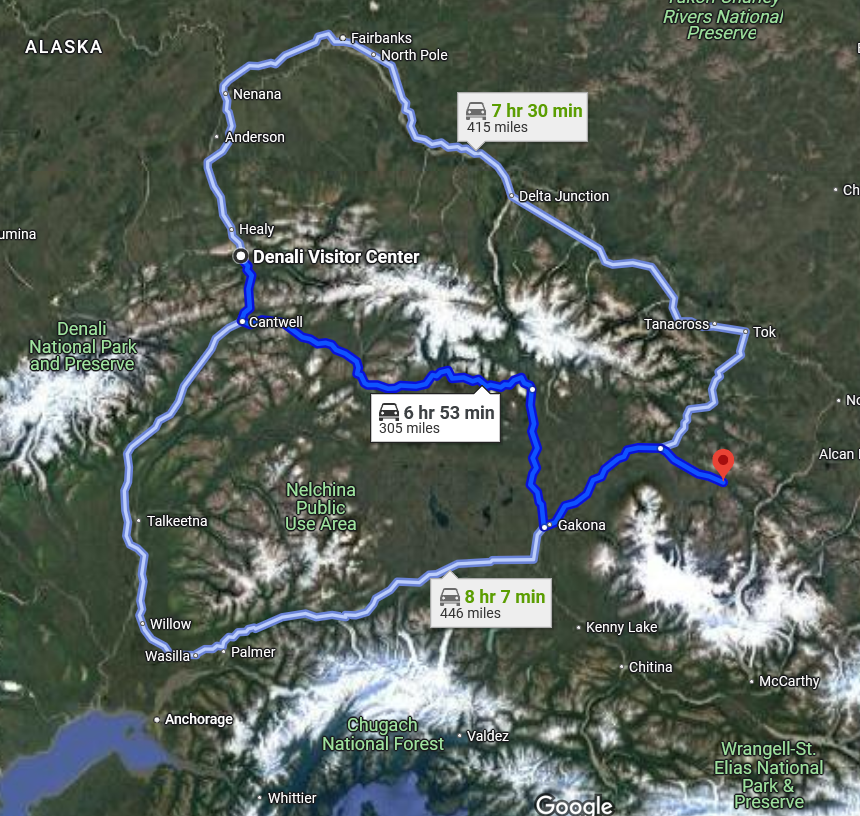
Routes from Denali NPP to Wrangell-St. Elias NPP by Google
A Scenic Odyssey
Spanning 135 miles between Cantwell (to the west) and Paxson (to the east), the Denali Highway (AK Route 8) offers sweeping views of (relatively) recently de-glaciated landscapes ringed by massive colorful mountains and icy rivers as you wind toward Paxson and the Richardson Hwy (AK Route 1). There are numerous prehistoric sites - some even dating to the Bering land bridge era- in this wild, untouched region. This route offers numerous scenic vistas, plenty of trails for stretching your legs, and a few quaint outposts in case you need assistance. Much of the route lies above timberline, providing expansive views of the Alaska Range's snow-capped peaks, rolling tundra, and glacial rivers. Highlights include Maclaren Summit, the second-highest highway pass in Alaska at 4,086 feet, and panoramic vistas of Mount Hayes (13,832’) and Mount Deborah (12,339’).
Points of interest noted in the map below (courtesy of our partner Bell’s Travel Guides):

Click on map to open a mile-by-mile guide.
An interactive map of the Denali Hwy can be found here for exploring numerous stops along the way: https://www.blm.gov/visit/denali-highway

Click the map for points of interest and descriptions
Transitioning to Wrangell–St. Elias National Park
Upon reaching Paxson, turn right (south) on the Richardson Highway / AK Route 4. This leg traverses the northern Copper River Basin, offering glimpses of the Wrangell Mountains (a.k.a. the Dancing Mountains because of how they seemingly appear to change places as you move around the basin) including Mount Sanford (16,237’) and Mount Wrangell (14,163’), an active volcano.

The Tanada Peaks and Mt Sanford from the Nabesna Road
Wrangell–St. Elias National Park: America's Largest Wilderness
Covering 13.2 million acres, Wrangell–St. Elias is the largest national park in the United States. It's a land of towering peaks, massive glaciers, and historic mining towns. Explore the remnants of the Nabesna and Rambler mines, hike the extinct Skookum Volcano, or take in the views of the Tanada Peaks. The park's vastness ensures solitude and a profound connection with nature. To dig in for more details, read our other article HERE.
Denali Hwy Travel Tips
Vehicle Preparation: Given the Denali Highway's partial sections of gravel, a sturdy vehicle with a full-size spare tire is recommended. Ensure your rental agreement permits travel on unpaved roads. The minimal cost difference to get out of the crowds is well worth the investment! Check our FAQ page for recommended agencies.
Seasonal Access: The Denali Highway is typically open from mid-May to mid-September. Always check current road conditions before departure with AK DOT https://511.alaska.gov/
Fuel and Supplies: Services are sparse along the Denali Highway. Stock up on fuel, water, and snacks before embarking on the drive. There are a few lodges along the way, call ahead for offerings.
Camping: Designated campgrounds are available at Tangle Lakes (MP 22) and Brushkana Creek (MP 104), with numerous pullouts for dispersed camping. Tangle Lakes CG has a great little hiking trail offering exceptional views. Great info HERE.
Embarking on this route offers an unparalleled Alaskan adventure, weaving through some of the state's most pristine and awe-inspiring landscapes.

There are so many unique places to visit for making exceptional memories. Read about some that are worth your attention in the neighborhood:

The Fountainhead Antique Auto Museum, Fairbanks
The Fountainhead Antique Auto Museum in Fairbanks is a wonderful place to visit with family and friends. The museum highlights survivor cars that made it to Alaska between 1910 and 1948. In the summer season, mid-May to mid-September, it is open every day, 11:00 a.m. to 5:00 p.m. Learn more here: https://www.fountainheadmuseum.com/

The UA Museum of the North, Fairbanks
The UA Museum of the North has a wide diversity of Alaska native art to polar dinosaurs, you will find something interesting on exhibit here. Head to the centerpiece of this museum, the Rose Berry Alaska Art Gallery, to see the full spectrum of Alaskan art, from ancient Eskimo ivory carvings to contemporary paintings and sculptures. Learn more here: https://www.uaf.edu/museum/

Alaska Wildlife Conservation Center, Girdwood
Alaska Wildlife Conservation Center is essential in rescuing injured and orphaned animals, conducting research, and providing awareness to the public. The center in Girdwood is home to black and brown bears, moose, caribou, coyotes, wolves, musk ox and other Alaska animals. The center has also partnered with the Alaska Department of Fish and Game over the last 20 years. Learn more at: https://alaskawildlife.org/

The Pioneer Air Museum, Fairbanks
In Alaska, pilots are held in such high regard, to get a feel for this and to learn more about Alaska’s early flight days, visit the Pioneer Air Museum in Pioneer Park. You will find logbooks, clothing, maps, early flight instruments, and aircraft sporting skis and floats adapted to rugged Alaskan runways in service to this essential mode of transportation. The museum looks like a round golden airplane hangar with a model aircraft from Air North mounted on beams outside in a simulated take-off. Inside, you will find a few of the earliest aircraft in the state from the 1930s and 1940s used in military, commercial, and bush flights. Learn more at: https://www.explorefairbanks.com/listing/pioneer-air-museum/10255/

The Alaska Aviation Museum, Anchorage
This museum presents a finest displays of Alaskan aviation history with interactive displays, memorabilia, photographs, films and artifacts from personal collections of Alaska’s pioneer aviators.

MOON LAKE STATE RECREATION SITE
Pack a lunch and swim gear and head to Moon Lake, a favorite local getaway. Learn more here: https://dnr.alaska.gov/parks/aspunits/northern/moonlksrs.htm

CLEARWATER STATE RECREATION SITE
A beautiful little campground lies tucked beside a crystal-clear river that offers great fishing opportunities and a peaceful place to spend the day. The clear waters of the Delta Clearwater River provide excellent fishing opportunities for Arctic Grayling, whitefish, and salmon. Learn more here: https://dnr.alaska.gov/parks/aspunits/northern/clearwatersrs.htm